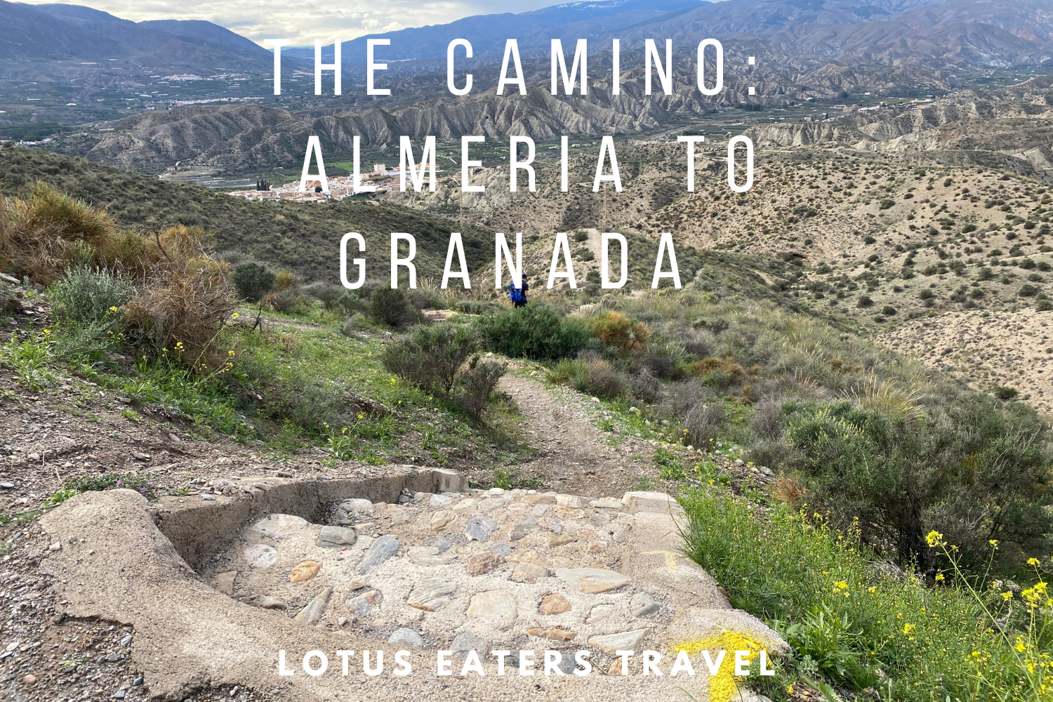
CAMINO MOZARABE: ALMERIA TO GRANADA DAILY STAGES.
The Camino Mozarabe runs from Almeria in Andalusia to Merida in Extremadura. From the south east of Spain, all the way to the western reaches of the country.
In this blog post, we will focus on the first section – from Almeria to Granada.
An ideal section to start, which takes in the white washed villages between the Sierra de Baza and Sierra Nevada, around the vast snowy mountain regions and of course the fabulous cities of Granada and Almeria.
We will set out our daily stages including a bit about the route, amenities you can find and lodging options for the evening. Alongside this, you can find our guide to 17 things you need to know about the Camino Mozarabe and our daily stages playlist on YouTube.


What’s the distance from Almeria to Granada?
The distance from Almeria to Granada is 197km along the Camino Mozarabe route. This includes 5000m of ascending and 4500m descending. Approximately 75% of this route is on trail (including farm tracks) whilst 25% is on road or pavement.
How many days does it take to walk the Camino Mozarabe from Granada to Almeria?
The typical daily stages allow for nine days walking from Almeria to Granada. It is possible to walk in less days – we did seven. And, you could also take more time, walking from town to town (where lodging allows), perhaps 10 or 11 days.
Typical daily stages for the Camino Mozarabe from Almeria to Granada
Typically, most walkers will spend nine days walking between Almeria and Granada in the following daily stages.
- Stage 1: Almeria to Rioja 15km
- Stage 2: Rioja to Alboloduy 23km
- Stage 3: Alboloduy to Abla 28km
- Stage 4: Abla to Huéneja 20km
- Stage 5: Huéneja to Alquife 19km
- Stage 6: Alquife to Guadix 22km
- Stage 7: Guadix to La Peza 22km
- Stage 8: La Peza to Quentar 27km
- Stage 9: Quentar to Granada 17km
These stages include lodging in the most significant towns on route, as well as balancing the distances.
If you want to mee the most pilgrims on route, the best way to do so is to walk the “typical” stages.
Highlights of the section from Almeria to Granada
Of course, there’s no requirement to follow the typical daily stages set out in guidebooks or GPS apps. When planning your own Camino Mozarabe journey from Almería to Granada, it’s important to consider the practicalities – like distance between stops and available accommodation – but I’d also encourage you to think about the special moments and places that will shape your experience.
Some stages may be worth stretching or shortening simply to hang out a little longer.
Here are a few of our favourite highlights along the way:
Alboloduy – 39km from Almeria

A tiny desert town that seems to appear out of nowhere, Alboloduy feels like a mirage rising from the arid landscape. There’s just one bar and a peaceful church, but that’s all you need. The municipal albergue is small but cosy, and the atmosphere is quietly magical, like being totally away from it all.
Abla – 68km from Almeria


A particularly pretty village where the streets are decorated with colourful crocheted doilies and yarn-bombed trees. It’s a charming place to stop, especially if you’re a fan of quaint details. There’s a great little tapas bar here, and the albergue is welcoming and warm – we arrived on a rainy day and couldn’t have felt more relieved to be there!
Huéneja – 88km from Almeria

While the albergue here is fairly basic, it’s worth it for the views of the Sierra Nevada alone. From the edge of town, the landscape opens out into sweeping mountain vistas – perfect for a morning coffee.
La Calahorra – 101km from Almeria


Crowned by a striking castle perched dramatically above the town, La Calahorra is no a fantastic stage for history buffs. The castle, with its backdrop of the Sierra Nevada, has even featured in film productions and TV shows (like the House of the Dragons).
Jerez del Marquesado – 111km from Almeria

Tucked into the foothills, this town is a quiet gem. Known for its sheep farming heritage, it has a rustic charm that’s hard to beat. We found a welcoming bar with a roaring fire – the ideal place to defrost on a chilly afternoon.
Guadix – 130km from Almeria


A real contrast to the smaller villages, Guadix is a bustling city with a fascinating mix of history and modern life. Don’t miss the imposing cathedral, but also take time to explore the cave houses and soak up the energy of the streets. It makes for a memorable end – or beginning – to a stage.
We didn’t stay in Guadix unfortunately, but have that down as our greatest “miss” of this trip!
Our daily stages from Almeria to Granada
We chose to walk from Almeria to Granada in seven days. Our daily stages and stops were chosen to meet a few criteria:
- We wanted each day to feel like a challenge;
- In total, we had 21 days to walk from Almeria to Merida, so allowed 7 days for this stretch – I know it’s not “ideal” to have a timeframe for the Camino, but for some people – that’s just how it is!
- We chose to stay in albergues with “hospitaleros” i.e. hosts, where possible. And, we picked towns that we were interested in staying in.
You can find details about our daily stages walking from Almeria to Granada below.
Day 1: Almeria to Almeria to Alboloduy
Key Details: Distance 39km, Ascent 909m, Descent 557m.
We hadn’t intended to start with quite such a long day, in fact we had planned to walk 36km to Santa Cruz de Marchena to the municipal albergue. We were persuaded by the wonderful Nely – one of the kind members of the Jacobean association who saw us off in Almeria – to walk to Alboloduy so that we could stay at an albergue with a hospitalero. This was a good decision! Even if it meant an extra 3km.
Most walkers will opt to split this section into two days – you can stay in either Rioja (17km)or Santa Fe de Mondujar (approx 23km). Both towns have accommodation.
ROUTE
The route starts at the grand cathedral in Almeria – a special place. Not least because of the large palm trees in the plaza. Quite a sight.


If you can, arrange to meet Nely and visit the Cathedral the night before you depart Almeria- we were offered the pilgrims blessing and it was something we will never forget.


You’ll head out of Almeria on quite a flat easy road and pavement, to Huercal de Almeria a – a town on the outskirts. As always, the route out of a city is never particularly pretty, but there are pops of bougainvillea and the odd tropical plant bringing colour to the first section of the route.
A riverbed allows easy walking until reaching Pechina. After the town and chance to stop you will re-join the river bed to Rioja.
It is after Santa Fe de Mondujar that the route gets juicy.
A steep climb leads to stunning, open scenery and incredible landscape. We were fortunate enough to have it to ourselves and that afternoon is one I will not forget easily. Not least, because there are three steep hills – each getting increasingly steeper.
Once down into Alhabia the walk is flat once again and follows a path down the side of a river bed all the way to Alboloduy.
AMENITIES
A good day for amenities with fairly regular stops available.
- Plenty of choices for breakfast in the centre of Almeria before leaving.
- Huercal de Almeria – cafes – 6.5km in
- Pechina – cafes and supermarket – 10km in
- Rioja – cafes and small mini-market – 17km in
- Santa Fe de Mondujar – cafes and supermarket – 24km in
- Alhabia – cafe – 32km in
- Alsodux – cafe – 34km in
- Santa Cruz de Marchena – cafe and Azahar pilgrims hostel (municipal) – 36km in
- Alboloduy – a small bar/ restaurant, mini-market, pharmacy.
ACCOMMODATION
In Alboloduy there are two lodging options.
The first is the municipal albergue – Albergue de Peregrinos Casa del Medico Alboloduy – which is found here on Google Maps. When we visited in March 2025, there was a hospitalero (a volunteer) and we were advised that we could arrive without notifying the association. At other times, there may be a code to get access to the building. As always with the municipal albergues, it is best to speak to the local association who manage the facilities.
You can find more guidance on accommodation on the Camino Mozarabe in our blog post here.
The albergue has two bedrooms with six beds in each and is operated on a donativo basis. There is a little lounge area, bathrooms and a kitchen that pilgrims can use.
A second choice is a private albergue Casas rurales el Albergue de Alboloduy. But, keep in mind that this is not really an albergue – more of a holiday home rental. You can book the entire house via booking.com – so this might suit a larger group of walkers.
If you choose to complete this stage in two days (as most walkers will) you can find a municipal albergue in Rioja (17km in) or La Posada Pilgrims Hostel in Santa Fe de Mondujar (23km in).
Day 2: Alboloduy to Abla
Key Details: Distance 29km, Ascent 912m, Descent 430m.
ROUTE


When we walked the Camino Mozarabe there were some terrible issues with flooding due to freak rain storms. As such, we were forced to take the road out of Alboloduy rather than the marvellous looking trail that heads through the valleys and crosses the Nacimiento river ravine.
If you have to walk the road route, expect a fairly quiet road at first. Later, a footpath runs alongside the busy highway – so it feels safe. But don’t expect the “road route” to feel easy – far from it, it still involves a lot of climbing, just like the normal route. And, taking the road is also slightly longer.
At Doña María , we expected to re-join the offical Camino route on the river bed, an easy walk to Abla. But unfortunately the river flooded right in front of our eyes, so we continued by road.
A final climb takes you into the centre of Abla, a beautiful town with a vibrant plaza.
AMENITIES
In Alboloduy the bar tends to open early and serves breakfast and coffee. We also stocked up on snacks at the mini-market.
The first amenities we encountered after this were in were in Doña María (21km in), where there is a small bar. Ideal for a coffee but perhaps not for food. Just over 1km later is Ocaña, which has a small bar (perhaps not the most reliable opening hours.) If you are walking the normal Camino route, you would reach the small town of Nacimiento before this.
In Abla, there are a few restaurants and bars. We were fond of Bar Plaza, an easy walk from the albergue for tapas.
ACCOMMODATION
In Abla, you’ll find the wonderfully named “Wolf Pilgrims Hostel”. A municpal donativo albergue with 12 beds. This was one of my fave places that we stayed on the entire route – there are views out to the Sierra Nevada from the terrace. On a cold day you can cosy up in the lounge and a warm day lounge on the terrace.
The albergue is manged by the Jacobean association, so you will need to contact them to receive a code to enter the albergue. And as always, a pilgrim credential is required. When we visited, we were offered a lovely breakfast to see us on our way.
Day 3: Abla to Huéneja
Key Details: Distance 20km, Ascent 500m, Descent 206m.
ROUTE


An easy 20km route, we were glad for it after the first two challenging days. Leaving Abla and walking along a road, you get glimpses of the Sierra Nevada alongside you, making even a straightforward walk feel special.
It’s worth noting that at Abla, there are two options. If the weather is good and your legs are strong – you may favour the slightly longer (but prettier) route which goes via Abrucena, rather than walking through Abla town onto the direct route.
After this, the route joined a river bed. Thankfully for us, this was not flooded. We did however acquire a stray Alsatian dog who followed us along the river to Fiñana. A charming town, with two lovely churches – one of which (Iglesia Parroquial) tends to be open.
For the remains of the day, the route tends to follow a river bed towards Huéneja. At La Huertzuela it is possible to take the road (as cyclists would) instead of the river route.
AMENITIES
- Fiñana – cafes – 7.5km in
- La Huertezuela – cafe – 14.5km in
- Hueneja – a lovely tapas place on the way into the town Cafetería Las Nogueras (The Albondigas were so good here that we ordered three plates for lunch!) There were limited bars open in the evening – we opted for Bar Waniya (where we ate yet more Albondigas).
ACCOMMODATION
In Huéneja we stayed in the Lobo Pilgrims Hostel which is rather a unique lodging option. Once again, this is an association run albergue operating on a donativo basis. There are 14 beds divided between two apartments. The apartment we stayed in had three bedrooms, the one we took had just one bunk bed (so a semi-private dorm room for us.)
The facilities are basic, but what made it so special are the views out to the Sierra Nevada. There’s also laundry facilities, a nice kitchen and a spacious dining table. Pilgrims are responsible for cleaning up when they leave, so of course you are encouraged to leave it looking spic and span.
Day 4: Huéneja to Cogollos de Guadix 30km
Key Details: Distance 30km, Ascent 665m, Descent, 675m.
Most walkers will split this day into two and stay in Alquife overnight. In all honestly, we didn’t like the look of Alquife and instead wanted to push on further. If you do want to stay in Alquife, there is a pilgrims hostel – Casa Lacho Hostel.
ROUTE


This was by far our favourite day on the Camino Mozarabe since we started in Almeria. Looking back, it is hard to believe that we saw such a vast change of scenery in just one day.
The route starts with easy walking along trail, backed by the impressive Sierra Nevada mountains. Villages like Dolar, look so wonderful in front of the snowy vistas and I couldn’t help but smile at the sight of them.
Beautiful trails continue, framed by olive groves. The walk into La Calahorra is particularly special, the imposing castle perched upon the hill is quite unreal. If you have time, it is possible to visit the castle, or spend a little while visiting the town that has been the backdrop to multiple TV shows and movies.

The walk into the mining town of Alquife is quite unremarkable but the countryside and climb into the quaint village of Jerez del Marquesado more than makes up for it. Along the way we saw fantastic farm scenes that reminded me of the book “Driving over Lemons” which is set in rural Andalucia.
Once up and over the hill the scenery suddenly changes, with the Cogollos reservoir in sight. A flat trail leads to the town.
AMENITIES
- The first town reached in Dolar – 5km in, where there is a lovely cafe and bakery a few doors down.
- Ferreira – bar – 10km in
- La Calahorra – multiple cafes/ bars – 14km in
- Alquife – cafe and shop – 20km in
- Jerez del Marquesado – lovely bar – 25km in
- Cogollos de Guadix – bar/ restaurant
ACCOMMODATION
Cogollos de Guadiz is not a typical pilgrim stop on the Camino Mozarabe and as such you won’t find an albergue in town.
We stayed at Hotel Reina Aixa – a boutique hotel in the town centre. Whilst it does have lovely rooms, it is a little on the expensive side. That said, we enjoyed a fabulous dinner at the nearby restaurant (owned by the same people as the hotel who were so welcoming).
If you do want to stay in Alquife, there is a pilgrims hostel – Casa Lacho Hostel.
Day 5: Cogollos de Guadix to La Peza
Key Details: Distance 34km, Ascent 698m, Descent 849m.
Most walkers will stay in Guadix overnight and then walk to La Peza. If we could change one thing about our trip, we would have stayed in Guadix.
ROUTE


The route starts on a quiet road leading out of town, sadly with the views of the Sierra Nevada mountains behind you. After this, a dirt track leads to Guadix for 12km. It is not the most exciting of walking, with little but clay banks to gaze it. Thankfully, it is easy walking and quick under foot.
At Guadix, you can follow the Camino route to walk around the edge of the city and see cave houses. Alternatively, you can take a more direct route to the impressive cathedral and central plazas to find amenities.
We visited Guadix in the morning when the cathedral wasn’t open and didn’t have time to linger, but I’d very much recommend doing so if you can. Guadix is thought to be one of the oldest Christian areas of Spain, and as such the cathedral has great importance.
The 7-8km into Purullena were totally different to anything experienced so far. A forested area with peaceful trails, then a walk through a gulley. Onwards to Marchal, and the route is unremarkable but for gaining altitude and seeing historic cave houses in the area.
After Graena, we encountered some wild dogs on the route that stopped us in our tracks and caused a re-route on road into La Peza (not something I’d recommend). Hopefully you will be luckier and be able to take the trail which descends nicely into La Peza.
AMENITIES
- Guadix – a large city with plentiful amenities – 12km in
- Purullena – lots of amenities, bakeries and cafes, ATM etc – 19km in
- Graena – a bar – 24km in
ACCOMMODATION
La Peza is home to the Alcalde Carbonero Pilgrims Hostel. A municipal albergue with 20 beds. It has a slightly odd location, I think located in a school compound. Inside is a great space, with a lounge area, a few rooms and bathrooms.
When we visited, the hospitalero Ray cooked a marvellous shared meal for the five pilgrims who were staying that evening. The next morning a breakfast was available too.
Day 6: La Peza to Quéntar
Key Details: Distance 27km, Ascent 881m, Descent 991m.
ROUTE


This is a very confronting and challenging day, but beautiful with it. If you have good weather and snacks with you, you will go well. But otherwise, it can be a challenge.

Out of La Peza, the route climbs until reaching an altitude of around 1,300m. A short descent leads down to a road, before once again climbing to the area around Collado de Puerto Blanco. I expect views are spectacular in this second half of the day, for us – we were battling with torrential rain and quite frankly couldn’t see much further than our noses!
The route starts the descent, which some may find steep, down into Quentar. The town was a very welcome sight for us!
AMENITIES
La Peza has a bakery which opens early. I’d recommend buying something to eat for the road ahead as there are no amenities until reaching Quentar.
ACCOMMODATION
There are two choices in Quentar, but no municipal albergue options.
For private rooms, consider Quentar Hotel Rural. An inexpensive hotel in the heart of the village. They allow check in from 13:00 which is very handy!
A second option is Fundalucia which offers bunk beds or twin rooms.
Day 7: Quéntar to Granada
Key Details: Distance 18km, Ascent 589m, Descent 773m.
ROUTE


This is a short day, but harder than we expected with significant climbs but quite frankly, magnificent, views.
The route starts easily enough with the descent and easy trail to Dudar After this, the climb starts. reaching a significant altitude. Even if it is a warm day, you may feel the chill at the top.

Whilst the climb is steep, it is worth it for the absolutely mind blowing views across the valleys. Eventually the route descends and gives us spectacular views towards the Alhambra as we enter the Sacramonte district (with the option to visit the Abbey should you arrive at the right time).
For us, this was a highlight and something we will remember for a long time. And if this is the end of your Camino Mozarabe, it is sure to feel spectacular.

AMENITIES
Quentar does have cafes, but all were closed in the morning when we left the town. Instead we continued 3 kilometres to Dudar where we found a coffee shop open.
After this, there are no amenities until you reach the outskirts of Granada. I’d recommend skipping the tourist cafes with the views that Alhambra and continuing to the city for better options.
ACCOMMODATION
Granada has an abundance of private accommodation, much of which is not super expensive.
The “classic” pilgrim choice is the Monasterio San Bernardo pilgrims hostel. An imposing building offering donativo beds. We met walkers who stayed here and spoke highly of it, but keep in mind that this isn’t the place to stay if you want to stay out late exploring Granada’s tapas scene.
We opted for a private apartment, which was surprisingly good value. This was a good chance to catch up on laundry and sleep! As well as enjoy a bit of independence to stay out late in the city.
Camino Mozarabe Guide Book
We also have a comprehensive 160 page guide book for sale in our shop. The book is available in an e-book format, ideal for reading on your phone as you walk.
Written by Emma
Wine Lover. Yogi. Hiker. Writer.


Do you need to book accommodation on the Camino Primitivo?
DO YOU NEED TO BOOK ACCOMMODATION ON THE CAMINO PRIMITIVO? PROS AND CONS. We walked the Camino Primitivo recently and after much debate, decided to book all of our accommodation ahead of time. While the Primitivo is often described as one of the quieter Camino routes, that reputation is becoming outdated. Throughout the summer we…
Taking the ferry from Laredo to Santoña: a short guide
TAKING THE FERRY FROM LAREDO TO SANTONA ON THE CAMINO DEL NORTE: A SHORT GUIDE. Walking the Camino del Norte along Spain’s northern coast brings many unique experiences. For me, one that stands out is the crossing the estuary from Laredo to Santoña by ferry. Despite being a quick journey, it’s a rare chance to…
How to Take the Pilgrim Ferry from Caminha to A Guarda (Camino Portuguese)
HOW TO TAKE THE PILGRIM FERRY FROM CAMINHA TO A GUARDA: A SHORT GUIDE. If you’re walking the Camino Portuguese Coastal Route, sooner or later you’ll reach the Minho River at Caminha and face a simple question: how do I get across to Spain? The answer, for most pilgrims, is the small tidal ferry that…
Most of our planning is done using other blogs, but you can’t beat a guide book at the bottom of your case.
Find them here on Amazon.

USEFUL LINKS FOR FLIGHTS, ACCOMMODATION AND TRANSPORT


CHECK LATEST FLIGHTS
ACTIVITIES TO CONSIDER
FOLLOW US ON SOCIAL MEDIA
Please note that some links on our website are partnered with affiliates. Using an affiliate links does not make it more expensive for you to purchase. We receive a small commission whenever you buy something which in turn allows us to keep writing independent travel guides and your support is greatly appreciated.