LAUGAVEGUR DAILY STAGES: OUR EXPERIENCE OF WALKING THE LAUGAVEGUR OVER FOUR DAYS.
Walking the Laugavegur Trail was something we’d talked about for months, an iconic multi-day hike through the Icelandic highlands, from the rainbow-coloured mountains of Landmannalaugar to the lush green valley of Þórsmörk.
It promised volcanic ridges, lunar landscapes, and hot springs – and it delivered. But it also gave us rain so heavy we lost visibility, snow in June, rivers that turned our feet to ice blocks, and the kind of camaraderie that only comes from shared Type 2 fun.


Our experience: Laugavegur daily stages
We walked the Laugavegur over four days in mid-June, choosing a mix of camping and one (unplanned) hut stay. Below is our honest, day-by-day breakdown of the experience, from snowfields to pancakes, hobbit holes to hidden hot chocolate sachets.
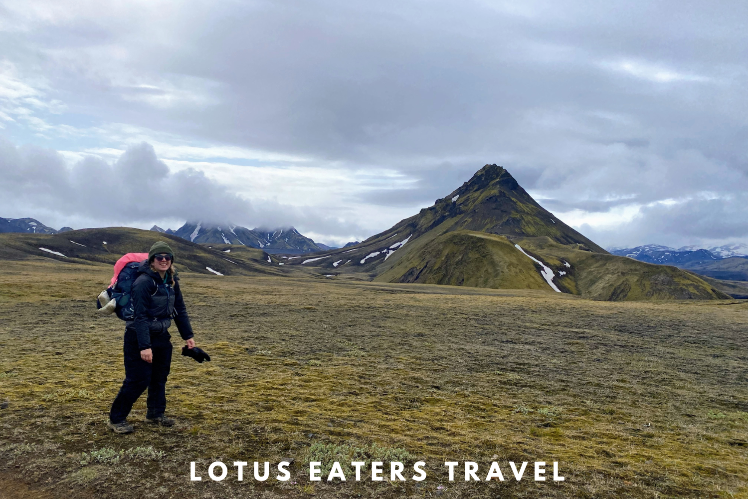
Day 1: Landmannalaugar to Hrafntinnusker

Route details & our experience
Distance: 12 km
Ascent: ~470m | Descent: ~0m
Time: 4–6 hours
“There’s not much snow up there,” she said with a straight face. Then, after a pause, “or at least, I haven’t heard too many people complaining about it.” This was our conversation with the ranger at Landmannalaugar before setting off on day one of the Laugavegur trail.
What she hadn’t disclosed, or perhaps we hadn’t asked the right question, was that later that day it would lash with rain so hard we’d lose all visibility. And that by the next morning, snow would be falling out of the sky. In June.


The trail starts off gently enough, winding away from Landmannalaugar on soft, undulating paths. The first 9 km pass easily. But it’s the final stretch – the last 4 km – that prove a challenge.


Suddenly, we’re trudging alone through endless snowfields. The weather turns again. My prescription sunglasses become useless, and I have to rely on John to guide me. He embraces his inner polar explorer and declares, with full drama, “We have to keep going or we’ll die.”
When we finally spot a sign telling us there’s just 1 km to go, we hug as though we’ve completed something far more momentous.
At the hut, we make a beeline for the ranger’s cabin, desperate to escape the snow and the cold. We’d planned to camp, but there’s no way. “Any beds left?” we ask. He nods, hands us the card machine, and processes the payment without ceremony. We joke about framing the receipt. He doesn’t laugh. Apparently, it’s only us who feel like we narrowly escaped a slow, snowy demise.
We arrive early, among the first trekkers. As the day wears on, the hut fills up. The vibe is… strange. Some people come in soaked to the skin, clearly unprepared. Others seem to be in a quiet kind of shock.
There’s no electricity, no internet, not even phone signal, so there’s also a fog of disconnection. A few people chat; others just stare into the distance, possibly regretting their life choices.
After hungry hiker suppers and a few board games, its time for bed. Gradually, we all settle into an uneasy silence, broken only by the occasional snore.
Route Notes:

Challenges: A long climb with several snowfields toward the end. In poor weather, visibility can vanish, having a GPS or offline map is essential.
Highlights: The vivid rhyolite mountains in the first few hours are breath-taking (note, if you want to see more of these, spend an extra day in Landmannalaugur). Reaching the hut, safe and sound, was also nothing short of magical.


Accommodation:
Hrafntinnusker is the highest and most basic hut on the route. No showers or running water when we visited (pipes were frozen), but a great kitchen and dorm space. Camping is possible, but it’s exposed and snowy even in June – not for the faint-hearted.
Day 2: Hrafntinnusker to Hvanngil


Route details & our experience
Distance: 18 km
Ascent: ~400m | Descent: ~900m
Time: 6–8 hours
We wake up late and lazy in the hut. Outside, it’s snowing, but inside, everyone is silently packing and prepping like it’s exam day. Some leave before 6am. We brew tea and drink it in bed, like we are in a hotel.
A sign outside the hut warns us about the ice chasms. “They might collapse underfoot,” it says, cheerfully.
We ask the ranger if today will be easier than yesterday. “Well, it’s downhill.” Hmm.

The reality? It’s uphill. For a good few hours. Through energy sapping snow. Again. We feel completely alone, just us and the wind, until we see two other hikers ahead. We share a brief moment of mutual despair and then they disappear over the next ridge.
Eventually, after what feels like forever, we start descending. Slowly, carefully. My knees are screaming. The wind is unrelenting. It’s beautiful, and feels like we can breath again, having successfully passed the “chasms.” It’s also cold. We don’t care about that either. What we do care about is the mythical restaurant at Álftavatn, which we’ve heard rumours of.

We arrive, elated, only to find it’s closed. Spirits sink a little. Even though, in all reality, we probably wouldn’t have bought anything – we just wanted the option.
At Álftavatn we meet a father and son from the US, in matching Decathlon waterproofs who’ve had a nightmare with delayed flights and lost luggage. They’re surviving on energy bars and blind optimism.
We press on, past the lake and into the next challenge: river crossings.
The first has a bridge. We rejoice. The second does not. It’s time for the wet water shoes. I resist the urge to throw a tantrum, like a toddler being asked to put on wet clothing. Across the river we encounter a German couple who hiked from Landmannalaugar to Álftavatn in one go. It’s about 14:00 and they’ve just started walking – I totally understand after the day they must have had yesterday.

Hvanngil finally appears. It looks like a mirage. Our pitch is sunk behind some rocks – a little hobbit hole of calm. A lovely Kiwi hiker offers to take our photo. We exchange cheerful weather chats and then she disappears to pitch her “castle.”


When I visit the ranger station to pay for our pitch, she offers free pancakes. I snatch them up before she changes her mind. “Yay pancakes!” screams the American dad as he enjoys his at the picnic table. Same, mate. Same.
We sit in our hobbit hole, gazing at the mountain, sipping hot drinks and eating baked goods in middle of Iceland, and everything feels right again.
Route notes


Challenges: Despite being downhill overall, this day felt really long. Poor visibility in the morning, soft snow, and multiple hills. The two river crossings slow things down, bring those water shoes and embrace the cold.
Highlights: Finally seeing colour again as you descend into the greener valleys. The contrast from the highland snow is stunning. Pancakes are an emotional high point.
Accommodation:
Hvanngil is a quieter stop than Álftavatn, with a charming little hut and sheltered camping. The vibe is relaxed, the rangers are wonderful, and the facilities are clean but simple. Peaceful and absolutely lovely.
Day 3: Hvanngil to Emstrur
Route details & our experience

Distance: 11 km
Ascent: ~100m | Descent: ~300m
Time: 3–5 hours
Only 11 km today – easy, right? Wrong. Our legs are heavy, and the trail undulates over endless ridges. Add a strong headwind, and it feels like a battle.

We find two Geordie lads huddled behind a rock. One of them mutters, “Stop sniffing yourself, mate,” which honestly sums up the collective hygiene levels at this stage. This is day three without showers for most; day six for us, having hiked the Hellismannaleið beforehand. I’m just glad he’s not sniffing me.


Every hilltop looks like it might reveal the campsite. Then finally, we see four hikers silhouetted on a massive mound. Our hearts sink – another climb? Turns out they’re off-route. “What’s up there?” we ask. “An amazing view,” they reply. So, naturally, we feel pressured to go up too. Social shame is a powerful motivator.
It was worth it.


Coming down, we see another hiker. “Amazing view up there,” we say. And just like that, the torch is passed.
Emstrur campsite is stunning – flat, riverside pitches, and a slightly festive feel. The ranger is wonderfully organised, with weather updates pinned up. She even advises where to pitch for the least wind.
The “cooking shelter” is a few picnic tables with no roof, and the wind makes it a bit of a laugh. We find two sachets of hot chocolate in the free food box and feel like we’ve won the lottery. That is, until we watch a guided group fire up a barbecue and crack open beers. I consoled myself with the knowledge that at least I’m losing weight.
Route notes


Challenges: Mentally tougher than expected. The trail is shorter, but windy with lots of small climbs.
Highlights: That unexpected view, the communal feel at camp, and the excellent ranger.
Accommodation:
Camping at Emstrur is on gravel but reasonably sheltered. The hut is small and popular – book well in advance. Facilities are basic but clean.
Day 4: Emstrur to Þórsmörk

Route details & our experience
Distance: 15 km
Ascent: ~500m | Descent: ~600m
Time: 5–7 hours
The final day, and things take on a celebratory tone. Early bird trekkers march past our tent exclaiming, “To Þórsmörk!” and waving like it’s the last leg of the Camino. We’ve been walking towards Þórsmörk for four days now and still have no idea how to pronounce it. “Thorks-more”? “Pork-smore”? We go with the latter – it amuses us more.

The trail begins gently and the scenery is immediately striking. Deep ravines, sweeping valleys, and distant green hills give a sense of scale we hadn’t quite felt on earlier days. It’s warmer, too. The landscape starts to soften slightly, and for the first time, we see real greenery – mosses, grasses, even a few scattered wildflowers.


Despite there being a giant tour group somewhere out there (we saw their matching buffs earlier), we lose people for long stretches and walk almost entirely alone. It feels peaceful and strange, like we’re the last people left on the trail.

We’d read there was a bridge today that wouldn’t be enjoyed by vertigo sufferers. In the end, there are two, so we’re not sure which one the warning referred to. The first is probably the culprit: it crosses a dramatic ravine, followed by a narrow cliff-edge path with a steep drop and chains to cling to. It’s a little hairy. The second bridge is a simpler wooden one over a river, but still not the best moment to look down.

Trees start to appear, slowly at first, then with more confidence. The dusty volcanic path gives way to grass, and finally, to a proper forest. After days of lava fields and dusty ridges, the birch trees and soft moss underfoot feel like stepping into another world. There are smells again. Birds. Shade. It’s a quiet, magical transition into Þórsmörk, a fitting end to the trail.

When you arrive, there’s a signpost and a sudden decision to make: which way to go? After a quick discussion, we opt for a 1.5km detour to reach the more glamorous campsite – the one with hot showers and a sauna. It also has Wi-Fi and phone charging, and being desperate for both, we don’t hesitate.


Within an hour, we’ve scrubbed ourselves clean, washed our hair, and are sipping on £10 beers while waiting for a £30 buffet dinner. The wilderness already feels like a distant memory.
Route notes
Challenges:
- There are two bridges today that may test anyone with vertigo. The first crosses a deep ravine and is followed by a narrow cliff-edge path with a steep drop – chains are provided for support. The second is a simpler wooden bridge over a river, but it’s still best not to look down.
- The final river crossing can be tricky – aim for the widest section, walk with the current, and use poles (or a buddy) for balance.
Highlights:
- Spectacular and varied scenery – dramatic valleys, colourful ridges, and finally, forest.
- The welcome sight of trees, wildflowers, and real signs of life.
- Arriving in Þórsmörk and indulging in a long, hot shower.
Accommodation in Þórsmörk:
There are three campsites to choose from. We stayed at Volcano Huts, which offers a bar and restaurant, sauna and hot showers, phone charging, and Wi-Fi.
You can stay in indoor huts, glamping tents, or pitch your own tent (as we did).It’s pricier than other campsites – we paid 7,800 ISK for one night (2 people) – but after four days in the wild, it felt entirely worth it.
Watch it
If you’d rather watch our journey on the Laugavegur trail, you can find it below.
Laugavegur Guide Book
Looking for a little more information? You can find our ebook in our shop. It includes 60+ pages of useful information about planning and preparing for the trail. As well as daily stages and route guides. The book also sets out how you can extend the Laugavegur to create a 9 day trek in Iceland’s Highlands.

Written by Emma
Wine Lover. Yogi. Hiker. Writer.


Laugavegur Trail in June: what to expect
LAUGAVEGUR TRAIL IN JUNE: WHAT TO EXPECT. When we were planning our trip to Iceland, we knew two things: we wanted to go in summer, and we wanted to spend about a month exploring the country. The plan was to complete a few long-distance hikes back-to-back – a full immersion in Iceland’s wild landscapes. When…
Food on the Laugavegur Trail: What to Expect (and What to Pack)
FOOD ON THE LAUGAVEGUR TRAIL: WHAT TO EXPECT & WHAT TO PACK. Hiking through Iceland’s highlands is unforgettable -steaming valleys, colourful rhyolite mountains, and snow-capped peaks everywhere you look. But it doesn’t take long before one thing starts to dominate your thoughts: food. Before tackling the Laugavegur Trail, we spent ages figuring out what to…
Our 5 Day Itinerary for Iceland’s Westfjords (2WD Friendly)
OUR 5 DAY ITINERARY FOR ICELAND’S WESTFJORDS (2WD FRIENDLY.) When we decided to travel to Iceland, we knew that we wouldn’t want to do the typical ring road. With ten days to spare, we decided to do something a little different instead – and headed to the far flung region of the Westfjords. And when…
USEFUL LINKS FOR FLIGHTS, ACCOMMODATION AND TRANSPORT


CHECK LATEST FLIGHTS
ACTIVITIES TO CONSIDER
FOLLOW US ON SOCIAL MEDIA
Please note that some links on our website are partnered with affiliates. Using an affiliate links does not make it more expensive for you to purchase. We receive a small commission whenever you buy something which in turn allows us to keep writing independent travel guides and your support is greatly appreciated.