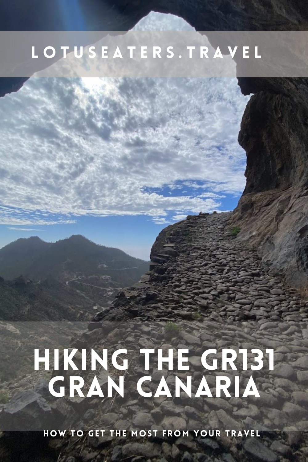
HIKING THE GR131 GRAN CANARIA: HIKING IN GRAN CANARIA A GUIDE.
We opted to start our 2024 hiking adventures with gusto by embarking on the GR131, a lengthy trail that spans across seven of the Canary Islands. Gran Canaria, being one of the largest and most captivating of the islands, unquestionably stood out as a highlight along the entire route.
This blog post sets out everything you need to know about hiking the GR131 in Gran Canaria including daily stages, refreshments and accommodation.
You may also want to read this alongside our GR131 Canary Islands FAQs post – found here.
Can you go hiking in Gran Canaria?

When you think about Gran Canaria, you might think about the buzzing city of Las Palmas or the typical fly and flop holidays. But, there’s more to Gran Canaria, especially for fans of getting active outdoors.
Hiking and cycling in Gran Canaria are really popular – get out on a Saturday morning and you’re bound to see half the island up and at em’ enjoying nature.
There are a number of shorter day hikes around the island as well as the GR131, which is the focus of this blog post.
What is the GR131 Gran Canaria?
This blog post focuses on the GR131 in Gran Canaria which we recently walked. The GR131 is a long distance hiking path that runs through seven of the Canary Islands, mostly coast to coast.
It is often referred to as an “island hopping” trail, because you need to take ferries to move between the seven different islands. The GR131 on Fuerteventura is also called the Camino Natural de Fuerteventura.
Is the GR131 the same as the Camino de Santiago Gran Canaria?
You might have heard about the Camino de Santiago in mainland Spain, well there’s also a Camino de Santiago route on Gran Canaria. The route is very similar to the GR131 route but there are some differences.
Both the GR131 and the Camino of Gran Canaria start in Maspalomas to the south of the island, but whilst the GR131 ends on the port town of Agaete, the Camino route ends in the more historic town of Galdar. The two trails take slightly different paths through the island as well. The Camino route is 66km, to the GR131’s 74km.
How long is the GR131 Gran Canaria?

The GR131 in Gran Canaria is 74kms (45 miles) long from start to finish according to the Cicerone guide. The All Trails map, which we followed, is 80km (50 miles) and we measured the route closer to 84km.
How many days does it take to walk the GR131 Gran Canaria?
The GR131 in Gran Canaria can be walked in three to five days. Speedy walkers might tackle it in three, but if you want a more leisurely pace then four or five is recommended.
In January 2024, we walked the GR131 Gran Canaria in three and a half days. Our daily stage guide can be found below.
What is accommodation like on the GR131 Gran Canaria?
The GR131 starts and ends in busy beach resorts, where hotels are easy to find. It travels through a few smaller towns and villages, where you can get accommodation. However, there are stretches with sparse accommodation, therefore camping is a great option for those wanting to hike the entire GR131 on Gran Canaria.
If you want to stay in proper accommodation, see the note below on how to do this by walking the route in four days.
We recommend booking accommodation ahead and planning your route carefully, if you do wish to rely on hotels rather than camping. We provide recommendations for hotels in the daily stages summary below in this post.
Can you camp on the GR131 in Gran Canaria?

Wild camping is prohibited on the Canary Islands. That said, many choose to wild camp when walking the GR131. This is because accommodation can be expensive on the islands and is often not conveniently located near to the trails. There are parts of the GR131 where there is little choice but to wild camp, as accommodation is sparse.
From our research, we are not aware of anyone who has had any trouble wild camping throughout the Canaries on the GR131. So long as you stick to simple rules – leaving no trace, no fire, camping away from the trail, avoiding private land and finally pitching at dusk and packing up at dawn.
It is not always easy to find a perfect wild camping spot due to the topography of the islands. In Gran Canaria particularly, we often struggled to locate flat ground, especially at higher altitude and towards the end of the trail. That said, we did successfully wild camp throughout the route and eventually found camp spots (they just weren’t quite as perfect as we wanted!)
How to get to the start of the GR131 Gran Canaria?
The GR131 starts in Maspalomas, a busy beach town in the South of the island.
If you arrive by ferry from Fuerteventura (if you’re walking the entire GR131) then you will need to take a bus from Las Palmas to the start of the trail.
Should you be flying into Gran Canaria, you will also need to take a bus or cab to Maspalomas from the airport.
You can find our guide to taking the ferry in the Canary Islands here.
Where does the GR131 Gran Canaria end?
The GR131 in Gran Canaria ends in Agaete/ Puerto de las Nieves, to the North West of the island. This is perfect if you plan to continue your GR131 adventures to Tenerife, as the ferries leave from here to Santa Cruz de Tenerife.
We used the app All Trails to navigate the GR131 throughout the Canary Islands – this is a great app, with an offline function that helps you to ensure that you stay on the route. It also has a great function showing the altitude and helping you to track distances to and from towns.
You do need to pay for the app, a yearly subscription – but we think it’s well worth it if you are planning to walk the GR131.
In addition to using a GPS map like All Trails, you will find red and white trail markers along the GR131. Each island uses slightly different sign posts and markings, but the red/ white is consistent. In our experience, Gran Canaria is well way marked but there are discrepancies between the All Trails map and sign posts towards the end of the hike (more on that below.)
Where to get food and refreshments on the GR131 Gran Canaria?

The GR131 on Gran Canaria goes through a number of towns and villages, normally at least one per day. Bars, cafes, restaurants and mini-markets provide the best opportunities to get refreshments. We recommend planning ahead to ensure that you have enough supplies, especially water.
You can find details on the amenities on route on our daily stages guide below.
Is the GR131 Gran Canaria hard?
We would describe the GR131 as a medium to challenging hike. It requires sure footing and an ability to tolerate steep ascents and tough descents.
Due to the Canary Islands’ topography, there are many changes elevation, narrow paths, and challenging sections, particularly in areas with steep slopes or loose ground.
On the GR131 Gran Canaria, some of the biggest challenges are the hill climbs.
The route is split into two halves – the first couple of days are spent ascending and the last day is a steep descent. The hardest section, in our opinion, is actually the descent on the last day – it took much longer than we had expected.
What is the terrain like on the GR131 Gran Canaria?
The terrain is mixed on the GR131 on Gran Canaria You’ll encounter a dusty trails, pine forests and mountain sections. Gran Canaria constantly keeps you on your toes.
Compared to other islands, like Fuerteventura, Gran Canaria is much greener – so you won’t have to walk through any deserts if you pick this island!
What to pack to walk the GR131 in Gran Canaria?
You can find our full packing list for the GR131 in our GR131 Canary Islands FAQ’s and planning post here.
GR131 Gran Canaria Daily Stages
We walked the entire GR131 on Gran Canaria in 3 and a half days. As we were wild camping, we often didn’t stop overnight near to any points of particular reference, but where possible we have tried to roughly indicate where we were able to camp.
Depending on your accommodation preferences and walking paces, you will need to plan and tailor your daily stages carefully – but we share ours below, which we hope will help to give you a sense of the route and to help you plan your adventure.
Day One: Maspalomas + 10km


KEY DETAILS: 10km/ 6miles, Ascent 100ft, Time 2 hours
As we had traveled from Las Palmas in the morning, then taken time to look around Maspalomas and stock up on supplies, we didn’t start walking until late afternoon. Subsequently, we kept our walk to just a couple of hours, before finding a camping spot.
ROUTE:
The route starts at the seafront in Maspalomas before crossing a dry river bed. After this, it follows a dusty track along a gully, popular with quad bike trips.
It is a flat and easy route out of town, with some interesting aspects – such as the aqueduct.
We followed the GR131 trail signs and the All Trails map, but we noticed quite quickly that this differs from the route set out in the Ciceron guide to the GR131.
We think that the Cicerone guide takes a wider and flatter route to Ayaguares walking mainly along roads, whilst the All Trails map provides a steeper and more interesting climb (see day two below.)
AMENITIES:
Maspalomas has a large number of amenities as a busy tourist town. You can find large supermarkets, restaurants, cafes and bars – most amenities are close to the beach.
After Maspalomas, the next available amenities (one bar) are found in Ayagaures.
ACCOMMODATION:
Accommodation in Maspalomas is easy to come by, just be sure to book ahead if you plan to stay there the night before your first walk.
After this, it is quite limited and many hikers resort to wild camping. You might find the occasional bed and breakfast or hotel like this one near to Ayagaures.
One of the reasons that we chose to camp only around 10km into the route, is that after this point the trail starts to ascend towards Ayagaures. There are lots of switch backs, which don’t make great camping space.
Day Two: 10km from Maspalomas to 6km short of Tunte


KEY DETAILS: 22km/ 14 miles, 2100ft Ascent, 7 hours
ROUTE:
The route starts with a series of switch backs as you climb towards Ayagaures. We expected this to take only an hour or two, but it actually took us closer to four hours before we reached Ayagaures itself.
After the mountain village of Ayagaures, you cross a dam before climbing further up the village. The trail continues to climb higher and higher into pine forests, providing space for a rest in the shade and a chance to find a camping spot if needed.
AMENITIES:
There’s one bar in Ayagaures, next to the church. A popular stop for hikers and cyclists, it has a really great atmosphere plus very reasonable prices. We had to try hard not to linger too long with beers before the climb after the village.
The next amenities are in Tunte (also called San Bartolmoe de Tirajana), some five or so hours walk, so we recommend stocking up on water at the bar before you leave.
ACCOMMODATION:
We chose to camp at around 5 or 6km short of Tunte when we found a flat bit of land available. If you want to stay in hotels/ B&Bs, Tunte is the best bet and it would be feasible to get there on the second day (provided that you reach Ayagaures by the end of day one.)
There are a handful of hotels in Tunte (San Bartolome de Tirajana).
Day Three: 6km sort of Tunte to Cruz de Tejada


KEY DETAILS: 24km/ 15 miles, 3000ft Ascent, 8 hours
ROUTE:
We started around 6km short of Tunte (San Bartolome de Tirajana) and were greeted with a steep climb initially, followed by a descent into the village.
Tunte is a quaint historic village, you’ll see many Santiago crosses symbolizing the importance of the village to the Catholic faith.
The village is also on the Camino de Santiago Gran Canaria route. After a breakfast and look around the famous church, we left the village via a footpath.


The path ascends steeply up into a pine forest, which thankfully offer a little shade from the sun. Many hikers climb up from Tunte to the Mirador at Cruz Grande. After this point, the route becomes quiet with even more steep ascents, punctuated with incredible views.
Eventually it flattens into pine forests again before meandering into Cruz de Tejada. There’s an option to detour to Tejada, but we stuck with the GR131 route to Cruz de Tejada to find our accommodation for the evening.
AMENITIES:
Tunte has a number of facilities, we enjoyed a long breakfast at the Panaderia. They will also make up sandwiches to go for the journey ahead. If you have time, you can enjoy a wine tasting at a Bodega just outside the village (here.)


ACCOMMODATION:
Cruz de Tejada is a tiny village with one restaurant and two hotels (both of which have restaurants too.) The Parador Hotel takes the most prominent position in the village, but we opted for the Refugio hotel which was a delight.
We enjoyed a three course supper in the restaurant with wine for around 25 Euros per head. Delicious after such a long day of walking and 3000ft of climbing!

Day Four: Cruz de Tejada to Puerto de las Nieves


KEY DETAILS: 28km/ 17 miles, 1100ft Ascent, 9 hours
ROUTE:
When we looked at the map today, we assumed it would be a gradual descent down from Cruz de Tejada to Puerto de las Nieves.
We were wrong. We assumed it would be an easy day of walking. This was also wrong.
Although it is a beautiful trail, there were times when we had to be extremely careful about our footing due to sheer drops and this rather slowed us down. We also took a short detour early on in the day, as we noticed sign posts indicating path erosion – luckily, a safer footpath was on offer.

After a fairly easy start to the trail, you arrive at Artenara. After this, the route leads into Tamadaba National Park. The park is beautiful, full of glorious pine trees and lots of hikers exploring, or enjoying a picnic.
We were quite surprised at this point to discover we were still at very high altitude,with only 10km to go. Suffice to say, the route drops quite steeply, before crossing the mountains and descending to the end of the trail.
AMENITIES:
Around two hours in is the small town of Artenara which has a supermarket and a few cafes/ bars. After this, Tamadaba National Park has a recreation area with toilets and picnic tables, as well as (non-drinking) water.
ACCOMMODATION:
Puerto de las Nieves offers plenty of choice for hotels and pensions. Agaete is a smaller village with not many options.
Daily Stages if reliant on accommodation
If you are planning to stay in accommodation on Gran Canaria, rather than camp, it is possible to do this if you walk the route in four long days.
Do note, the distances here may sound easy but with the terrain and hill climbs you do require plenty of time – the last day for example may take 9-10 hours.
| From and To | Distance | Hotels |
| Maspalomas to Ayagaures | 21km | In Ayagaures – found here. |
| Ayagaures to Tunte (San Bartolome de Tirajana) | 13km | In Tunte – found here. |
| Tunte to Cruz de Tejada | 17km | In Cruz de Tejada – found here |
| Cruz de Tejada to Puerto de las Nieves | 27km | In Puerto de las Nieves – found here. |
Where to next on the GR131?
The GR131 is a long-distance island hopping route. Find all our resource for the GR131 here:
- GR131 Planning – all you need to know to prepare
- GR131 Fuerteventura
- GR131 La Gomera
- GR131 + GR132 – a circular hike in La Gomera
- GR131 Gran Canaria
The tropical island paradise that is perfect for hiking


Interested to find an alternative to hiking the GR131 in Gran Canaria? We’ve recently discovered the tropical island in Europe that we think is the number one island paradise for a hiking vacation.
Find out more about our new favourite hiking destination here.
Written by Emma
Wine Lover. Yogi. Hiker. Writer.


Join our subscriber list for new posts with awesome travel tips. Don’t miss them!
Subscribe below to our newsletter for tips, thru hiking, adventures and insights to places unseen.
Canary Islands in January: what to expect
CANARY ISLANDS IN JANUARY: WHAT TO EXPECT. I make no secret of how much I love a bit of winter sun, or indeed the Canary Islands. Having visited several times in both the shoulder and peak seasons, I was curious to see what they were like in winter, when much of Europe is huddled under…
15 best hikes in Europe for April
15 BEST HIKES IN EUROPE FOR APRIL. April is a wonderful month to enjoy hiking in Europe, whether you’re looking for a long distance trail or a few days of trekking. But, you have to pick wisely to find the best hiking weather. In the north, trails might still be snowbound. But head a little…
10 Hiking Routes in Europe for December: chasing the sun
10 HIKING ROUTES IN EUROPE FOR DECEMBER: CHASING THE SUN. Late last December, we set out to walk the Fisherman’s Trail. A long distance hiking trail that wraps around the very south western point of Portugal and takes in the best of the Algarve. Not a day went by when we didn’t pinch ourselves, feeling…
Something went wrong. Please refresh the page and/or try again.
USEFUL LINKS FOR FLIGHTS, ACCOMMODATION AND TRANSPORT


FOLLOW US ON SOCIAL MEDIA
Please note that some links on our website are partnered with affiliates. Using an affiliate links does not make it more expensive for you to purchase. We receive a small commission whenever you buy something which in turn allows us to keep writing independent travel guides and your support is greatly appreciated.
2 responses to “The GR131 Gran Canaria: A guide to hiking in Gran Canaria”
[…] Gran Canaria […]
[…] Best hikes: Roque Nublo is a popular hike or consider the GR131 […]