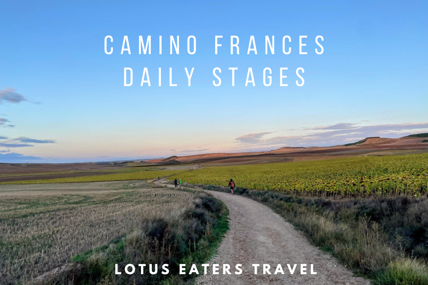
CAMINO FRANCES STAGES: HOW WE WALKED THE CAMINO FRANCES IN 27 DAYS.
In September 2023, we finally walked the Camino Frances. Having completed many of the other routes ,it felt only right to tackle the most popular one.
In this guide you can find the exact daily stages that we walked – including our reflections on the route, our accommodation choices and a guide to amenities along the way.
Camino Frances Stages Route Map
Camino daily stages PDF – our daily stages and the typical ones
You can download a PDF with the Camino daily stages below.
Camino Frances: Long daily Stages
The below are the Camino Frances stages walked by the Lotus Eaters Travel Team in September 2023. These are generally a little longer than the typical daily stages.
Whilst these Camino Frances stages may not suit everyone, we share with you a summary of each of our Camino Frances stages to give you a sense of the route, amenities and accommodation at each stage and to help you plan your Camino Frances stages.
Day One: Saint-Jean-Pied-de-Port to Roncesvalles 24.7km


Route:
- Ascent 1480m/ Descent 726m
- Trail 7.92km/Road 17.3km
We had expected a climb today, but hadn’t realized quite how challenging it would be. Despite a short distance covered, this was quite a long day of walking. This is a really tough day on the Camino, arguably the hardest on on the entire route. We suggest starting early to avoid the sun and pacing yourself. Many people we met had pushed themselves too hard on the first day and ended up with injuries. Also, do note foot care on your first day.
🦶For more information on foot care on the Camino, find our short guide here.
The route starts on road, exiting SJPP and fairly soon you start to climb. The road turns to moorland, with a mix of paths, tracks and some slightly rocky terrain.
On foot, this is very manageable and pleasant terrain, much less so for those cycling the Camino. On the day that we walked, the sun was shining and there was very little shade around during our climb.
Walking through France is a short lived experience, as today you will cross the border into Spain. There is nothing to mark the border, but you can find it on googlemaps in case you do want to celebrate the crossing!
Roughly around 6km from Roncesvalles, you will start the descent. This is pleasant, with some shade provided by trees but it can become muddy if it has been raining. There are also some loose rocks, making the climb down a little technical.
Highlights:


- There is such an electric feeling starting in SJPP and knowing that you are finally on your Camino adventure. Everything felt like a highlight today.
- The scenery as you enter the Pyrenees is breathtaking, a reward for the climb
- Wildlife surrounds you – fantastic birds of prey and wild horses
Amenities:
SJPP has a number of bakeries and a large Lidl Supermarket (which opens early.) It’s best to stock up and buy lunch for the route. Along the way, there is an albergue in Orison which sells food and refreshments and also has a toilet.
🚽Speaking of toilets, if you want to find out more about bathrooms on the Camino, you can find our guide here.
Elsewhere, you may find a refreshment van at the top of the steep climb in the Pyrenees. Do note, it may not be there all day/ every day, but it’s pleasant surprise if it is! We spotted two water taps along the route too.
Accommodation:


We stayed at Roncesvalles pilgrims hostel, an iconic albergue on the Camino Frances.
For many pilgrims walking the Camino Frances, this will be the first albergue experience after the first day of walking from SJPP to Roncesvalles. It may be one of the largest albergues you come across on the Camino Frances, with 183 beds set over three floors.
The albergue is set on a huge historic complex, attached to a church. Arriving here feels like a very special moment, not least after trekking over the Pyrenees.
The albergue offers a communal dinner and a breakfast, alternatively there are vending machines or a few restaurants & bars in town.
How to book: It is best to book in advance to stay here. Although it is a large albergue, many people choose to stay in Roncesvalles and therefore it can become fully booked during peak season. Reserve beds online through the albergue website here.
Day Two: Roncesvalles to Larrasoaña 26.7 km


Route:
- Ascent 998m/ Descent 544m
- Trail 18.7km/Road 8km
We were woken at 06:00 in our albergue, the lights come on and music is piped into the room. There was no sense in hanging around, so we got an early start heading out in the dark.
Many people walk just to Zubiri today, but we pushed on a little further to get near to Pamplona ahead of day three. It felt quite good to break away from the pack and get away from the typical “daily stages” as the first day had been quite busy with walkers.
The route crosses two mountain passes, Alto de Mezquiriz and Alto de Erro before descending into Zubri. The climb down to Zubri feels quit technically challenging, due to the rocky surfaces. Many found this a challenging climb and in wet weather it can be quite treacherous.
After Zubri, the route to Larrasoaña is fairly flat and pleasant, along trails and easy roads.
Highlights:
- We really enjoyed the descent into Zubri today but many people find it quite challenging under foot
- Most of the paths were shady and on trail (rather than road) today
- Larrasoaña is a quaint town, there’s a river as you walk in which make a wonderful spot to relax and bathe your feet at the end of the day
Amenities:
In the first 5km (approx) from Roncesvalles, there are a few villages with cafes. After that, and before Zubri there is a 7km gap with no amenities apart from an over-priced food truck.
Accommodation:


There is a municipal albergue in the town which cannot be booked, it does get full in the summer and peak season but they will try to find you a space with a mattress.
We opted for the Albergue San Nicolas, a small albergue run by a young couple and their dog. We found it to be a really friendly and clean albergue. Set a little way away from the river and the municipal albergue in a peaceful location.
The albergue offers a wrap around terrace space and the albergue has great facilities inside (well placed plugs and small dorm rooms.)
Be sure to take the generous three course dinner, a communal supper is always a great way to meet people early on in the Camino Frances.
How to book: You can book via their website, find it here.
Day 3: Larrasoaña to Pamplona 14.8km


Route:
- Ascent 328m/ Descent 275m
- Trail 8.9km/ Road 5.9km
We opted for a short day with a walk of less than 15km into the city of Pamplona. This was a fairly easy walk with a few ups and downs, but nothing significant.
There is a route split today, but it is just a slight detour to Zabaldika. This is only recommended if you’re staying there. We stuck to the main route.
One of the highlights of walking the Camino fur us, is to visit the wonderful Spanish cities on the way. Others choose to skip the cities, perhaps walking in for breakfast or lunch but not staying.
It is a totally personal choice, depending on your preference for exploring versus losing the feeling of being on the Camino (a night in the city can feel a bit too much like being back in the normal world!)
If you choose one city on the Camino Frances, we do recommend Pamplona. A stunning city and very easy to explore in an afternoon.
🏤If you’d like to know more about the cities on the Camino including what to do in Pamplona, find our guide here.
Highlights:


- The charming town of Villava, just short of Pamplona where we stopped for our usual coffee and breakfast break after walking 10kms
- Entering Pamplona is an incredible feeling as you walk around the city walls
- Enjoying pincho and wine in Pamplona, Bar Gaucho (found here) is a must visit for the most exquisite pincho
- Visiting the Cathedral in Pamplona (do note that it closes at 18:00.)
💡It’s best to avoid eating on any of the streets where the Pamplona bull runs take place, bars on these streets tend to be a little over-priced.
Amenities:
You’ll find a cafe early on into the walk to Pamplona at Zuriain, then there is a short gap (of around 5km) with no amenities, before you reach the town of Villava at around 10km in.
Accommodation:
There are albergues in the city, including a donativo (Albergue Diocesano Betania.)
Personally, when we travel to cities on the Camino, we prefer to go for a normal hostel as opposed to an albergue. The reason for this is that hostels tend to be more central in the city, they can be booked well ahead and they don’t have a curfew. T
his means we can stay out late and enjoy the city. Staying in a hostel , rather than albergue, is a good choice if you want to stay longer in the city too.
Aloha Hostel Pamplona is a centrally located backpackers hostel with a cozy and bright feel. Beds offered for 20 Euros. Albergue Plaza Catedral is another bookable option in a central location with dorm beds for 20 Euros.
Day 4: Pamplona to Puente La Reina 23.7km


Route:
- Ascent 470m/ Descent 574m
- Trail 13.6km/ Road 10.1km
The initial walk out of Pamplona is on road and pavement. You walk through a number of suburban towns before reaching the trail. Despite only a 470m climb today, this was quite a rough walk and the winding trail up is rather steep.
Upon reaching the top of the hill, you will see the Alto del Perdón sculpture. The perfect moment for a break, especially if the mobile refreshment van is at the top.
We loved the climb down after this, but the gravel under foot can make it slippery and we heard that others found this a challenging descent.
Highlights:


- Taking a moment to enjoy the incredible views from the El Alto del Perdón sculpture at the top of the hill – this is an iconic photos spot on the Camino Frances. The sculpture depicts the history of the Camino
- We met the Guarda Civil who work specially to help pilgrims along the Camino – if you see them, ask for a special police stamp for your credential
- Entering the Navarra Wine region
Amenities:
There are plenty of cafes at regular intervals on the route. We couldn’t resist stopping for lunch at the Camino del Perdon Hostel in Uterga – stop here for delicious tortilla. There are no big supermarkets on route, but we found one small grocery shop.
Accommodation:


Puente La Reina is a great sized town with a few different accommodation options. Padres Reparadores Pilgrims Hostel is the largest with 92 beds and a nice garden.
We chose to stay in Estrella Guia Hostel, a modern and brightly colored hostel with a great terrace. You can book this on booking.com.
Day 5: Puente La Reina to Vilamayor de Monjardin 31.2 km


Route:
- Ascent 869m/ Descent 546m
- Trail 24km/ Road 7km
This was a great day of walking with mainly trail often through vineyards, but there were some steep climbs to tackle. At Vilateurta, there’s an option to take the normal route to Estella or an alternative trail.
We took the alternative trail and whilst it was scenic, it was very tough to walk (many climbs) and we had to cut back to the main route to find the wine fountain. We recommend sticking to the main route trough Estella.
After Estella, the route takes you past Bodega Irache. A wine maker that famously offers a free wine fountain for pilgrims (found here.)
Highlights:
- Drinking from the wine fountain just past Estella (do note, if you stay in Estella, it’s easy to walk past this in the dark in the morning – we found it at 14:00, which was much more fun!)
- For wine lovers, there’s also a fantastic winery in Vila de Mayor – Bodega Castillo – pop in before 19:00 for a glass of local Navarre wine.
Amenities:
There are plenty of cafes and coffee shops at regular intervals today, as well as a few large supermarkets. We started to notice today that there were some very overpriced cafes on route, look out for this.
Accommodation:


Many people stay in Estella, which is a pleasant town. We continued to Vila de Mayor.
In Vila de Mayor, there are two albergues and one pension. We stayed in Villamayor de Monjardin Hostel – this was an okay place to stay, but unfortunately the communal dinner is offered to only 10 pilgrims and we missed out.
Although there are restaurants in town, it’s a shame to miss out on a chance for communal dinner. If you choose this hostel, be sure to arrive early.
The other albergue in town is Albergue Oasis Trails which is very popular and has great outdoor space. If we visited this town again, we would choose to stay here.
Day 6: Vilamayor de Monjardin to Logroño 39.8km


Route:
- Ascent 563m/ Descent 867m
- Trail 28.1km/ Road 11.7km
This was our longest day on the Camino Frances so far and in retrospect was a little too much so early on into the Camino. We woke up to crazy lightening storms and our original plan to set off early was hampered by this -it’s best to avoid walking in lightening when it’s close by so we took shelter and waited it out for a few hours.
Once we eventually got going, this was a really pleasant walking day, with footpaths meandering through (very muddy) vineyards. There were a few hill climbs, the reward for which was spectacular views over the vines and surrounding countryside.
The last few kms into Logroño is on asphalt and this was particularly punishing at the end of a long day. But, we enjoyed entering the city through green space and seeing The St James Way rose (grown especially for the city) in full bloom.
Highlights:
- Crossing into the Rioja region today, home to one of my favourite wines (although the “welcome to Rioja” sign is not placed in the most glamorous of settings in front of a factory!)
- Enjoying a few glasses of wine in Logroño next to the imposing Cathedral and meandering through Calle de San Juan (Tapas Street) – note this doesn’t really get lively until around 20:30.
Amenities:
There is a 12km gap between Vilamayor and Los Arcos where no amenities can be found. It’s best to pack something to eat or eat before you leave in the morning. In Los Arcos, there are a few cafes and small supermarkets.
Look out for some very over priced options directed at pilgrims in the town and instead head to local bakeries.
Further on, Viana has plenty of amenities, including a water fountain. The last 10km to the city has nothing, so be sure to fill up on water in Viana if you are making the push on to Logroño.
Accommodation:
In Logrono, we broke with out usual tradition of staying in a backpackers hostel in cities and we booked into a pilgrim albergue instead. We found a great value spot on the outskirts of the city, Albergue Albas. We booked a little via Whatsapp. Do note, this albergue is a bit out of the way – around 20 minutes from the Cathedral.
The municpal albergue is much more central – found here, but do note that you will need to arrive early to get a bed.
The city can be particularly busy on the weekends and we recommend booking ahead if you can. If you plan to spend more than one night in the city, we can recommend Winderful Hostel, a boutique hostel in the centre of the city.
Day 7: Logroño to Nájera to 28.3km


Route:
- Ascent 439m/ Descent 324m
- Trail 20.2km/Road 8.1km
We enjoyed a slow breakfast in Logroño and watched the city wake up.
The route exits the city slowly for around 3km and enters a pretty park (another chance to see the St James Way Rose). In the morning, locals exercise in the park and it’s a very pleasant environment. Look out for the pretty lake as you walk through.
The route eventually enters fields, many filled with vines before entering the town of Navarrete. On route from here to Najera, there’s a long section of trail which is quite easy walking.
Highlights:
- The wine fields of Rioja – although it was disappointing not to find anywhere on route offering a wine tasting.
- Najera is a quaint town, with a few restaurant and bar options to enjoy in the evening. There is also a very grand monastery, we didn’t visit but others did and were very impressed.
Amenities:
Between Logroño and Navarrete (12km away) there are no facilities. The same goes for between Navarrette and Najera (16km). Watch your water supplies and stock up in Navarette – a small town with cafes and supermarkets.
Accommodation:
We enjoyed a very comfortable evening at Albergue Puerta de Najrea – book via Whatsapp or Email. This Albergue is probably the best in town, a private albergue that feels more like a fancy house than a hostel.
The owner comes around in the evening and personally adjusts the windows and shutters ready for bed. There’s also a nice communal space, where we were able to enjoy a bottle of Rioja in the company of other pilgrims.
There is a municipal albergue in town, but it’s not in the best location, away from the historic centre of town and the monastery.
Day 8: Nájera to Redecilla del Camino 31.9km


Route:
- Ascent 590m/ Descent 348m
- Trail 23.7km/ Road 8.20km
Most will walk to Grañón today, a famous town in Camino terms, with an interesting donativo albergue. We decided to push on, mainly to get a bit of distance under our belts. But, we would recommend staying in Grañón if you can.
From Najera, the day starts with a steep climb up a sandy hill with 5km until the next town of Azofra, which didn’t have an inviting vibe.
The town after this is Cuiruena, which has a few cafes. However, the town of Santo Domingo de la Calzada is beautiful, with a large Cathedral and pleasant square. The final town of the day, Grañón is also very attractive.
In between the towns, the route is mainly on trail with some incredible open scenery today. After Grañón it’s time to leave the small province of La Rioja and enter the large expanse of Castile and León.
Highlights:
- Fields of sunflowers on route – in September they are passed their best, but still nice to see. In the summer, I imagine they create stunning fields of yellow.
- Lunch stop in Santa Domingo de la Calzada
- Jose’s hospitality at Albergue Essentia
Amenities:
There are a good amount of facilities on route today, with a number of water fountains available. The large town of Santa Domingo de la Calzada is an excellent place to stop for lunch. A food truck in Grañón offers a delightful cold beer 5km before the final destination.
Accommodation:
Redecilla del Camino is a slightly strange town, with a few houses and two albergues but not much else. The best days may be behind it since the main road was built, with just a few residents remaining.
That said, we stayed in Albergue Essentia and had an excellent night. This is a small albergue, with only 10 beds. Jose, the owner has opened up his home as an albergue.
The atmosphere is fun and a bit eccentric, a true “Camino experience” with a home cooked communal dinner where we all exchanged Camino stories. We highly recommend this place, if you do find yourself in Redecilla del Camino.
Day 9: Redecilla del Camino to Villafranca – Montes de Oca 23.5km


Route:
- Ascent 391m/ Descent 200m
- Trail 16.8km/Road 6.7km
The route today was very flat and fairly easy. A little mundane at times but mostly trails. We visited many towns throughout the day, some made more interesting by the Camino street art decorating the walls.
We stopped at 23km because we were aware that there was a large hill with a 12km trail coming up after this point and we didn’t think we had the legs for it. In retrospect, we should have continued as the hill the next day was not so challenging and Villafranca – Montes de Oca was not the best town to stop in.
Highlights:
- Some excellent Camino art throughout the day
- Enjoying a menu del dia in the evening at El Pajaro
Amenities:
There are frequent small towns with cafes at regular intervals throughout the day, although we did not find any supermarkets.
Accommodation:
Villafranca – Montes de Oca is perhaps not the prettiest town, ruined slightly by a busy road running through the town. But, it is a really welcoming town with nice restaurants and a bakery.
It has a few albergues, but we opted for a Penison (Pension Jomer) as we were in need of a good sleep in a private room. A basic place, but good value for money and can be booked via booking.com.
Day 10: Villafranca – Montes de Oca to Cardeñuela Riopico 24.5km


Route:
- Ascent 409m/ Descent 423m
- Trail 19.6km/Road 4.9km
The route starts with a fairly steep climb up a trail before flattening out. In total there are around 12km of trails through woods, perfect to shield from the sun.
At San Juan de Ortega, there is a choice of paths. The left path is 0.8km longer, but a prettier alternative. The right path (more suitable for cyclists), runs along side a main road. We took the longer route, a more rural alternative and mostly trail. However, the longer trail was quite challenging under foot at points.
Highlights:
- The long 12km trail in the morning was really enjoyable and meditative walking
- A large communal dinner in Via Minera, accompanied by lashings of red wine
- The church in Cardeñuela Riopico is incredible, a small parish but with an elaborate renaissance facade
Amenities:
There are a few small towns on route, but note that the first 12km is without amenities. There was a man giving coffee for a donation on the trail but there are no guarantee that he is always there. The towns of Atapuerca and San Juan de Ortega are pleasant places to take breaks throughout the day.
Accommodation:
This tiny town has two albergues. We picked Via Minera. When we initially arrived, we weren’t too impressed as the pictures on the website were a little deceptive. That said, it ended up being one of the best albergues we stayed in when it comes to value or money. The bed and dinner were very inexpensive compared to other hostels, albeit the facilities are a little outdated.
Day 11: Cardeñuela Riopico to Rabé de las Calzadas 26.6km


Route:
- Ascent 155m/ Descent 253m
- Trail 4.3km/Road 22.3km
A flat route today, dominated by road or pavement walking. After about 10km, we reached the city of Burgos. The route into Burgos was fairly industrial, we passed tire factories and other commercial buildings.
We would normally choose to stay in cities on the Camino, but opted out of doing this in Burgos. Instead, we arrived just in time for breakfast in the centre of town and enjoyed seeing the city on a slow Saturday morning. Although there is a grand Cathedral, Burgos is not as pretty as the other cities on this route.
From Burgos, we left via a slightly run down park before officially entering “The Maseta”, the area of plains that many pilgrims dread. From this point, the towns become less frequent and there is less shade available.
Highlights:
- Breakfast in Burgos
- A fiesta in Rabé de las Calzadas
Amenities:
Burgos is the best place to stock up or enjoy a break. After this, there is around a 10km gap to the town of Tardajos.
Accommodation:
We stayed in Albergue Liberanos Domine. A clean and small albergue on the town square. The albergue offers dinner, but there is a tiny communal space/ dining area so we chose to eat out and enjoy the local fiesta (a little more lively than we expected, it was still going strong when we started walking the next morning!)
Day 12: Rabé de las Calzadas to Castrojeriz 27.3km


Route:
- Ascent 338m/ Descent 363m
- Trail 20.6km/ Road 6.7km
A fairly easy route with trails through fields of sunflowers, some surviving late into the season and putting on a show. Quite a lot of trail walking and minimal on the road today. We visited some charming towns, including Hontanas. A barren trail leads to Castrojeriz, via the interesting ruins of St Anthony’s monastery.
Highlights:
- Lunch in Hontanas – an upmarket town, delightful even in the rain
- The ruins of the Monastery of St Anthony a few kms short of Castrojeriz are worth a visit (you can also stay in a basic albergue here too)
- Entering Castrojeriz, a pretty town
Amenities:
There are two large towns on route today, Hornillos del Camino and Hontanas. Both are popular places to stay. Hontanas is a beautiful town, one of the prettiest on this section of the Camino. We noticed a few lovely lunch spots and a quite upmarket hotel (stay there for some Camino luxury!)
The distances between the towns are quite large however, keep this in mind when planning water supplies and food.
Accommodation:
We stayed in Albergue Orion in Castrojeriz, one of our favourite places on the Camino. We chose this as we had heard about the amazing Korean meal offered,this did not disappoint. The albergue was also clean and very comfortable.
Day 13: Castrojeriz to Villalcázar de Sirga to 38km


Route:
- Ascent 346m/ Descent 348m
- Trail 30.9km/ 7.2km
A very mixed day of walking with plenty of trail rather than road walking. The hill out of Castrojeriz presents a challenging climb But this was a very special moment climbing in the dark and watching a stream of pilgrims with head torches coming up the hill. From the top of the hill at 1100 metres, the sunrise is a spectacular sight to see.
There’s an alternate path towards Itero del Castillo, but you don’t need to take this path unless you are staying there. The first facilities we found were in Itero de la Vega, where we stopped for a delightful breakfast. After this, you will walk though the town of Fromista.
At Poblacion de Campos, there’s another split in the path. There is 1 km difference between the two paths, the longer option which goes via Villovieco has more shade. We opted for the shorter path and it was a nice trail.
For the last 4 or 5 kms of the route today, the path becomes quite mundane as it runs alongside the road. Unfortunately this continues into the next walking day too. But at least it is easy walking!
Amenities:
There’s a smattering of bars and restaurants at regular intervals today but note that the first 9km has no facilities. A large supermarket can be found in Fromista, directly on the route.
Highlights:
- The morning hill climb and scenic views at sunrise
- Walking along the river towards Fromista, opportunities to swim in certain spots
Accommodation:
We stayed in Don Camino hostel, a small family run hostel with a pretty garden and a decent restaurant/ bar. This can be booked via booking.com or via Whatsapp/ Email.
Day 14: Villalcázar de Sirga to Calzadilla de la Cueza 22.7km


Route:
- Ascent 126m/Descent 72m
- Trail 16.10km/Road 6.5km
The route today for us was short after a long day previously. There is a large gap on the route today (17km) with no albergues, which is quite unusual for the Camino Frances.
Therefore, we decided to stay in the first town after this. In retrospect, we could have walked further as the route is very flat and easy going.
The highlights of the route are probably the town of Carrion de los Condes early on. Beyond this, the walk feels quite mundane and there is little shade to escape the sun. We were delighted to see the town of Calzadilla de la Cueza over the horizon – like a mirage trying to trick us. After the heat of The Meseta, the swimming pool at the Camino Real albergue beckoned us.
Highlights:
- Carrion de los Condes is a lovely town – very lived in and authentic with lots of cafes. We recommend heading further into town to find the local cafes and avoid the “pilgrim”ones just off the Camino.
- Arriving at Albergue Camino Real – such a lovely atmosphere
Amenities:
The route today is sparse when it comes to amenities. There is a lovely town, Carrion de los Condes, at 5km with many cafes and supermarkets. After this, there is one coffee stand (with no bathroom) the 17km of trail in The Meseta.
Accommodation:
In this small town, there are a few options. The Municipal Albergue, The Camino Real Hostel and a friendly bar are side by side, creating a really lovely complex around which pilgrims gather. We opted the Camino Real Hostel which was absolutely one of our favourite places to stay on the Camino.
The owner of the hostel is so friendly and the atmosphere is wonderful, plus there’s a refreshing swimming pool in the fantastic garden.
Day 15: Calzadilla de la Cueza to Bercianos del Real Camino 32km


Route:
- Ascent 250m/ Descent 258m
- Trail 27.3km/ Road 4.7km
Another relatively straightforward and flat day in The Meseta. After 6km in Ledigos, the route splits. The slightly longer route is a lovely and secluded trail which we really enjoyed. The other route is shorter but goes alongside the road.
The walk into Sahagun is a little frustrating as you must take a detour to avoid the main road, you can see the town in the distance but there’s a convoluted route to get there. Nevertheless, arriving in the halfway point is very nice.
There’s also a pretty and shady park just before the town, if you have lunch with you this is a great place to stop for a break.
Later in the route, there’s a choice of two roads. The Old Roman Road is 32km from Calzada del Coto. It promises to be quite pretty but you can only really take it if you stay in Calzado and you are happy to walk the next day with no facilities on the trail.
To get to Bercianos del Real Camino, you must take the main trail. We took this choice and felt it was a good decision.
Highlights:
- Excellent tomato on toast in a café in Ledigos
- The secluded alternate route from Ledigos where we saw Bodegas (underground wine storage) which look a bit like hobbit houses
- Hitting the official halfway point in Sahagun – many pilgrims choose to get their “half way certificate” (the Carta Peregrina) at this point and this is also a popular place to stay
Amenities:
There are regular amenities today, the first to encounter is in Ledigos where there is a cosy café serving breakfast. Sahagun is a large town with supermarkets and cafes too.
Accommodation:
Bercianos del Real Camino has a Municipal Albergue and a private. We opted for the private albergue called La Perala Hostel. This was a great place to stay with a fantastic huge garden and a decent bar/ pilgrim menu. It was one of our favourites -we’ve written more about it here.
Just short of Bercianos is another municipal albergue, San Roque. It is a small and very quiet albergue, but we chose not to stay as it was a little too quiet for us with only two or three pilgrims staying there even during peak time. But, we recommend it if you want to get away from the crowds.
Day 16: Bercianos del Real Camino to Reliegos 20.2km


Route:
- Ascent 80m/ Descent 107m
- Trail 13.8km/ Road 7.3km
A short and flat walking day, we had planned to walk further but were hammered with rain and ever the fair weather walkers, we decided to stop early.
The route was quite homogeneous all day, a tree lined path running alongside the road. Pleasant, but fairly mundane too. The path has some light gravel, making it less of a challenge on the feet than walking on asphalt.
Highlights:
- Stopping for our first coffee and a break from the rain in El Burgo Ranero
- Arriving in Religeos and finding a wonderful albergue and a chance to get dry
Amenities:
El Burgo Ranero (7km in) has some nice cafes, otherwise sparse for the day until Religeos
Accommodation:
We stayed in Albergue La Parada. A private albergue run by a young couple. A really great albergue with excellent facilities and well thought through layout. The pilgrim menu was delicious – slightly different to other menus we had had and a welcome change. You can book via email.
Day 17: Reliegos to León 24.6km


Route:
- Ascent 205m/ Descent 195m
- Trail 15.6km/Road 8.9km
A short and flat industrial route into Leon, the walk was fairly non-descript. Entering the city is really exciting as you start to see the mix of interesting Art Décor and Gothic architecture and to feel the typical buzz of a Spanish city.
You can spot the fellow pilgrims dotted around the city easily, with backpacks and sandals in contrast to the well heeled locals.
In Leon, the Cathedral is absolutely stunning. Be sure to visit and perhaps take the audio tour if you have time, it offers a fascinating insight into the building. Plaza Mayor is an enjoyable open square where you can enjoy drinks and food.
There’s also a reasonably priced Museum of Modern Art (MUSAC), which is a little way out of the centre but an interesting thing to do in the city for 3 Euros.
Highlights:
- The town of Mansilla, 6km short of Leon was really pleasant
- Arriving in the city of Leon. We decided to reward our progress so far with a delicious tasting menu at a Michelin guide restaurant in Leon (If this sounds like something you would like, you can find out more about that here.)
Amenities:
The town of Mansilla offers a number of amenities and there are frequent shops and other outlets on the outskirts of Leon. There are also hiking and clothing shops in the city, which may be of use if you’re experiencing a weather change or need to replace any of your hiking gear at this stage.
Accommodation:
There are many choices in Leon, from pilgrims hostels to private rooms. The albergue near to the Cathedral, Leon Hostel, is a popular choice. We opted for Rua 35, a very reasonably priced private room with a shared bathroom.
Day 18: León to Hospital de Obrigo 31.8km


Route:
- Ascent 243m/ Descent 266m
- Trail 17.4km/14.4km
I don’t mean to sound negative, but this was possibly one of the most boring days of walking on the Camino Frances today. There is an option to take a more scenic route, which in retrospect we should have done. However, the scenic route is 3km longer and therefore we chose the less interesting one.
We started on the outskirts of Leon today, working our way out of the pretty city through a residential area. The route we took followed mostly along the side of road, but on trail. A straight and fairly repetitive walk.
Highlights:
- Modern church on the outskirts of Leon with statues outside
- We enjoyed coffee at a pleasant coffee stand at around 12km out of Leon – there was some really fun music and a great atmosphere with pilgrims enjoying drinks outside
- Arriving into Hospital de Obrigo really surprised us, especially the incredible bridge on the outskirts of the town and the beautiful cobbled streets
Amenities:
Plenty of cafes and supermarkets on the outskirts of Leon as you leave the city. A couple of coffee stands and restaurants along the route. For the last 10km we saw only one water fountain and not much else before reaching Hospital de Obrigo.
Accommodation:
The town of Hospital de Obrigo has a number of albergues, one with an excellent rated restaurant (Albergue San Miguel). We stayed at Verde Hostel, which was a unique experience. There was a yoga class offered in a fabulous shala, a home cooked organic supper of fresh bread, chickpea curry and home grown tea.
After a cup of sleepy tea and a relaxing evening in the garden, we were all soundly asleep by 21:00 before lights were even out. A relaxing and very zen place to stay. Book via email or on the phone.
Day 19: Hospital de Obrigo to Rabanal del Camino 35.5km


Route:
- Ascent 516m/ Descent 194m
- Trail 20.4km/ Road 15km
After Hospital de Obrigo, there are two choices of route. From Albergue Verde, there’s a handy gate at the back so you can get access to the Camino more easily and you can choose either one. We were told that the shorter route was (predictably) the more boring one, running alongside a road.
Whereas, the second route runs through a number of small villages and then through a footpath with a donativo coffee place. We opted for the more scenic. This takes 17km to Astorga rather than 15km.
The donativo coffee place on the hill was a highlight, offering fruit and various other snacks and refreshments. This is a community of people serving the Camino and it felt very friendly and a treat after a long climb.
After Astorga, the route goes into a wild and long trail. There is very little and you need to remember to top up on water. We really enjoyed this stretch of walking, but it felt quite poignant remembering that Denise Thiem was brutally murdered on this stretch of route. A reminder of how lucky we are to be able to walk in safety and to reach our destination.
There’s not much shade available on this route, as well as few amenities after Astorga.
Remember to collect your stone after Murias de Rechivalod when you start the climb. A pilgrim tradition is to collect a stone in this area and to bring it up the hill to Cruz de Ferro where you will leave it.
Highlights:
- The view to Astorga and then arriving in Astorga itself. In retrospect, we wished we had the chance to stay in the city but we enjoyed a slow breakfast there instead. Be sure to visit the Cathedral and to see the Gaudi Palace. And of course, taste some chocolate. A famous delicacy from Astorga.
- Seeing fences covered in crosses, which felt particularly poignant all along the route. A reminder of every pilgrim who had traveled this path.
- Arriving to Rabanal del Camino, a stunning village
Amenities:
Through to Astorga, there are many facilities. But we recommend waiting to Astorga to enjoy a breakfast or lunch if you can. What a beautiful place. After Astorga, there is little available, so do make sure you have plenty of water for the route.
Accommodation:
We stayed at Pilar Nuestra Albergue. This is a private albergue but on the cheaper end at 10 Euros per bed. This was our first experience of bunk beds actually touching, almost to make double beds.
For us, this was a nice experience, but for others we imagine this would be very odd if you end up with a stranger practically in your bunk. But, at least the body heat will warm you up in the cold room – it was freezing and there were no blankets available. We’ve heard there are better albergues in the town, Guacelmo Shelter, to name one.
Day 20: Rabanal del Camino to Ponferrada 32.2km


Route:
- Ascent 621m/Descent 1226m
- Trail 21.4km/ Road 10.7km
This day was one of the toughest but most rewarding days on the Camino. The climb and descent is tough, but the scenery is glorious.
The incline is quite steep to start the day. After Rabinal and once the climb starts to flatten at around 5.5km, you will find a cute little mountain town called Foncebadon.
All the places here had an almost hipster vibe, playing great music on a blue sunny day in the mountain. We felt totally elated, especially after the first climb. You will reach the Iron Cross at Cruz de Ferro, where you can place your rock and then the climb starts to descend.
The descent is quite steep and can be difficult under foot. We noticed a few people losing their footing and tumbling (thankfully no injuries). Take it steady down the hills.
The next town after the descent has a great vibe, El Acebo. We stopped here for a tortilla sandwich and enjoyed a lolloping dog roaming about the place.
Highlights:
- Breakfast in Foncebadon and enjoying the mountain air
- The descent down to El Acebo
- Finally arriving to the large town of Ponferrada, with the castle and cathedral to explore before enjoying dinner at a pizza restaurant in town
Amenities:
Plenty of amenities but some large gaps to watch out for, a few people were caught short without water just before Ponferrada. Be sure to carry plenty with you.
Accommodation:
We opted for an albergue we booked on booking.com – Albergue Alda. We knew it would be a long day and wanted something booked upon arrival. The albergue is great, spacious and comfortable with lots of light. However, it is not on the best side of town for restaurants and exploring. On the plus side, it is right on the Camino route for the next morning.
Day 21: Ponferrada to Trabadelo 34.1km


Route:
- Ascent 528m/ Descent 505m
- Trail 7.5km/26.6km
A day with some undulating climbs and walks around vineyards. There are a few optional routes today. The first, will take you on a variant to Valtuille de Arriba, rather than direct to Villafranca. Both are good options with around 1km difference.
After Villafranca, there is a choice to take a steeper but shorter route to Trabadelo. We took the flatter route, not the most scenic, but we heard the steep route is really challenging and takes one hour more – best to take it only if you have the energy!
Highlights:
- Wineries on route – check out Don perdon Bodega and Villas Del Biazo (where local rose is sold for 2.75 Euros per bottle)
- The charming town of Vilafranca del Bierzo with a food market
- A friendly and cosy night spent at Casa Susi
Amenities:
A few small towns on route, Villafranca being the largest. Look out for wineries on route. The last 9km into Trabadelo has no amenities.
Accommodation:
We had heard about Casa Susi and were so delighted to get a booking there. This was one of our fave albergues on the Camino Frances and for good reason. The hosts have turned their home into a glorious albergue for pilgrims.
A total escape. If you can get booked in, be sure to stay here. Otherwise, Villa Franca has a few albergues and Trabadelo some with private rooms.
Day 22: Trabadelo to Fonfria 30.2km


Route:
- Ascent 1329m/622m
- Trail 14.05km/ Road 16.1km
Today was one of our best days of walking on the Camino Frances. The flat Meseta feels like a distant memory as we climb the hills and cross into the green and lush province of Galicia.
The route starts fairly easily, along a road but you wind through many small villages. It becomes greener and lusher and you notice more cows and dairy farms.
The climb up to O Cebreiro feels endless, but the scenery gives you constant feedback and a much needed boost to keep going. Past O Cebreiro, the route continues to climb eventually reaching 1,300m. Mostly, the route is open and easy to walk.
Highlights:
- Scenery for the entire day today is epic, lush green hills and vast valleys
- O Cebreiro, the top of the hill and a charming mountain town
- Our stay at A Reboliera was excellent, lively and heart warming dinner and comfortable beds.
Amenities:
Plenty on route today. Be sure to stop in O Cebreiro if you can. A small mountain village at the top of the hill, famous for it’s goats cheese and an excellent place to stop for lunch. Many choose to start their walk here.
Accommodation:
We stayed at Albergue A Reboleira, a large mountain albergue with space for around 70 pilgrims in two dorms and 11 private rooms. There is a communal dinner, well worth attending, with three course and wine included.
The design of the hostel is brilliant, offering mountain chalet vibes and quite upscale design features for a hostel. Bunks are sturdy and comfortable with some privacy.
The bar is also very reasonably priced. The outdoor space is perhaps the best bit, with sun loungers and picnic tables to enjoy relaxing outside in the mountain air.
Day 23: Fonfria to Sarria 36km


Route:
- Ascent 591m/ Descent 1428m
- Trail 21km/ Road 13km
The route today was supposed to be 34km, but actually measured 36km for us. Longer than expected. Despite this, it was an enjoyable day of walking with plenty to take in. The start of the walk is a descent from Fonfria, with excellent views across the Galician countryside.
The route splits, with most pilgrims choosing to take the longer route into Samos to see the monastery – well worth it.
Highlights:
- Views from Fonfria – try to avoid walking in the dark if you can, the sunrise was spectacular
- The monastery in Samos, take the time to get a tour
- Arriving into Sarria, which has an upbeat vibe and new energy as ore pilgrims join for the last 100km
Amenities:
Many villages along the route, Samos makes a nice stop for lunch. Be careful on the last 10km or so into Sarria, which does not provide much by way of amenities.
Accommodation:
Sarria has perhaps the most choice of any town on the Camino Frances. However, it can be wise to book ahead as many pilgrims join here and are likely to make bookings. The municipal albergue Xunta de Galicia Sarria has 40 beds and does not take bookings, but you will need to arrive early to get a bed.
Day 24: Sarria to Ventas de Naron 35.6km


Route:
- Ascent 918m/ Descent 663m
- Trail 19.2km/ Road 16.4km
A long day of walking today, made slightly harder for us as one of us was dealing with a fever and stomach bug.
The route out of Sarria was very crowded and felt quite overwhelming, but soon the crowds spread out. Hoards of new people joined, notable by everyone adjusting new backpacks and putting on various plasters to cover fresh blisters. But, it felt exciting to have an injection of new people to join us.
The route out of Sarria is not easy, with quite some steep climbs to tackle. The climb into Portomarin is tough, especially with a step flight of stairs to the town.
Many pilgrims stop in Portomarin for the day, so after this point we did not see many people for the rest of the day. A few nice trails awaited us and one or two more climbs before reaching Ventas de Naron.
Getting off the “main Camino Frances stages” after Sarria is a great way to avoid crowds and the race for beds. Ventas de Naron was a very quiet place to stay offering quiet walking in the afternoon and following morning.
Highlights:
- The energy from new pilgrims when leaving Sarria
- Portomarin town is friendly and a great place for lunch
- The last part of the day was quiet and peaceful on some trails
Amenities:
From Sarria, there are many amenities along the way. It is difficult to walk more than 304km without finding a new cafe or albergue.
Accommodation:
We took an inexpensive private room at Casar Molar, a quiet albergue serving a hearty meal. The host speaks no English, which led to some amusing exchanges between pilgrims who spoke no Spanish and the host.
Day 25: Ventas de Naron to Melide 26.3km


Route:
- Ascent 408m/ Descent 654m
- Trail 17.9km/ Trail 8.4km
Not a particularly difficult day of walking, but we encountered a hot day. Fortunately, there are some lovely stretches of shady trail today. We passed through a few villages an the main town of Palas de Rei. Most people split this day with a stop in Palas de Rei, so from there to Melide was very quiet. But the town was buzzing when we arrived.
Highlights:
- Melide is a fun town with loads of seafood restaurants
- Our albergue was a real treat, with a private room and a swimming pool
Amenities:
Plenty on route, water fountains in Palas de Rei and supermarkets too.
Accommodation:
We opted for a quiet private room at a Lua do Camino. A clean and spacious albergue with a delightful swimming pool. There are plenty others to choose as Melide is the meeting point for the Primitivo route as it joins the Frances.
Day 26: Melide to Salceda 25.2km


Route:
- Ascent 538m/ Descent 622m
- Trail 19.8km/ Road 5.4km
Some trail through woods as you leave Melide, this can be quite unnerving in the dark. We suggest leaving after sunrise. Some undulating terrain, before arriving to Arzua. After this, trails through woods are pleasant before arriving to Saleda.
Highlights:
- Busy town of Arzua, where the Camino del Norte merges.
- We had walked this stretch before and enjoyed reminiscing
- Enjoyable conversations with pilgrims joining from the Primitivo and Camino del Norte
Amenities:
Vast numbers of bars and cafes on route. Limited supermarkets and water fountains however.
Accommodation:
Salceda is a small town and we suggset booking ahead. Many places are available on booking.com. We like Albergue Turistico Salceda, with a swimming pool.
Day 27: A Salceda to Santiago de Compostela 27.8km


Route:
- Ascent 537m/ Descent 639m
- Trail 12.7km/ Road 15.1km
We have walked this section before and remembered it being quite flat, but it is not. The day is quite undulating. But the excitement carries you through and the walking was fast for us. A mix of trail and some road walking, with some areas less scenic (as you walk past the airport.) Eventually, you can see Santiago in the distance and you start the emotional descent into the city.
Highlights:
- The view into Santiago from around 5km back is special
- The energy all day was amazing and of course, entering to the Cathedral
Amenities:
Vast numbers of bars and cafes on route. Limited supermarkets and water fountains however.
Accommodation:
There are many choices in Santiago. For a traditional albergue, we like The Last Stamp (El Ultimo Sello). For inexpensive private rooms, we like Hostel Mafer.
🏙️Find out more about what to do in Santiago here.
Would you like more info on the Camino Frances?
We’ve got an Ebook packed full of information about the route. This includes a guide to accommodation, all the cities on route and more route daily information.

Find it here in our shop and download it today.
What should you pack for the Camino Frances?
We’ve written a comprehensive guide to what to pack for the Camino. This includes answers to all your questions, from “do I need a sleeping bag?”, to “how much should my backpack weigh?” and everything in between.
🎒Find our Camino packing list here.
Where to next on your Camino journey?
Looking for Camino souvenirs?
We wanted to create Camino merchandise that we would actually wear ourselves. On the trails, out and about or at home. Keep it classy.
You can find all our items in our Etsy store – Camino Nostalgia.

Santiago coordinates t-shirt – multiple colours.

Camino Class of ’24 & ’25 sweater – multiple colours.

Ladies Camino Class of ’24 Tee – multiple colours
Written by Emma
Wine Lover. Yogi. Hiker. Writer.
British travel writer and long-distance hiker, native to Kent. Emma has walked the Camino de Santiago more than ten times, completed trails across Europe from the Corfu Trail to the Fisherman’s Trail, and covered thousands of kilometres on foot. She always writes from first-hand experience. Her goal? Inspire just one person to go on their first long-distance hike.


15 alternatives to the Camino de Santiago
15 ALTERNATIVES TO THE CAMINO DE SANTIAGO. The Camino de Santiago has become something of a legend. It is the route that introduces many people to long-distance hiking for the very first time. And year after year, it is growing in popularity. But once you have experienced the rhythm of trail life, the absolute joy…
25 mistakes I’ve made on the Camino de Santiago
25 MISTAKES I’VE MADE ON THE CAMINO DE SANTIAGO. I think one of the reasons people romanticise the Camino de Santiago so much is because, in many ways, it deserves it. There’s nothing quite like strapping my backpack on and setting out on the start of a Camino journey. Some of my favourite memories moments…
26 things to do to get ready for your first Camino de Santiago
26 THINGS TO DO TO GET READY FOR YOUR FIRST CAMINO DE SANTIAGO. Planning your first Camino can feel overwhelming. There’s a lot of advice out there, and it’s not always easy to know where to start. But, you don’t need to have absolutely everything figured out before you go. This list is based on…
Most of our planning is done using other blogs, but you can’t beat a guide book at the bottom of your case.
Find them here on Amazon.

USEFUL LINKS FOR FLIGHTS, ACCOMMODATION AND TRANSPORT


FOLLOW US ON SOCIAL MEDIA
Please note that some links on our website are partnered with affiliates. Using an affiliate links does not make it more expensive for you to purchase. We receive a small commission whenever you buy something which in turn allows us to keep writing independent travel guides and your support is greatly appreciated.
11 responses to “Our 27 Camino Frances Stages + Map / PDF”
[…] was about to buy a new backpack for my upcoming Camino Frances walk in September, when I remembered the Osprey Almighty Guarantee. My backpack was just over one […]
[…] visited A Coruña for a few days after finishing the Camino Frances in Santiago. A Coruña is a wonderful place to visit alongside visiting Santiago de Compostela. The […]
[…] written extensively about the different Camino routes, and we are fortunate to have walked the Frances, the Norte, Portuguese Coastal and Portuguese Central route. For this reason, I was very interested […]
[…] Find out more about the Camino Frances, including the distance, route and daily stages here. […]
[…] your daily stages – our guides to the Portuguese route, Frances and Norte may […]
[…] quite challenging, training before is recommended. We are regular hikers and had just completed the Camino Frances prior to the Lycian Way, so felt sufficiently […]
[…] is variance of numbers across the routes that you ought to consider. In 2023, the Camino Frances was nearly as busy in September as it was in August (just 1,000 people less.) Whereas, the […]
[…] stage with plenty of facilities, then 1 litre (35 fluid ounces) may be enough especially on the Camino Frances. Check the facilities in advance so that you can plan accordingly. Also, if it’s particularly […]
[…] a more recent 800km plod across Spain, in conversation with a fellow hiker, I confessed that I was walking for research, each step I took […]
[…] This was day one for us – find out more here. […]
[…] city of Logroño on the Camino Frances, has an annual celebration dedicated to it’s patron saint. This year, it will be held between 08 […]